

Water level fluctuations are the result of tide, wind-driven waves, swells, tidal surges and long waves covering a wide range of frequencies which may differ greatly in space and time.
Typical sea level variations causing coastal hazards are:
- Mean sea-level rise due to climate change
- Extreme sea levels during a storm
- Tsunamis
- Meteotsunamis: Large waves that scientists are just beginning to better understand. Unlike tsunamis triggered by seismic activity, meteotsunamis are driven by air-pressure disturbances often associated with fast-moving weather events, such as severe thunderstorms, squalls, and other storm fronts. The storm generates a wave that moves towards the shore and is amplified by a shallow continental shelf and inlet, bay, or other coastal features. A single meteotsunami can travel long distances and can affect very large stretches of coastline.
- Infragravity waves or seiches: Standing waves with longer periods of water-level oscillations (typically exceeding periods of three or more hours), whereas meteotsunamis are progressive waves limited to the tsunami frequency band of wave periods (two minutes to two hours). Seiches are usually limited to partially or fully enclosed basins.
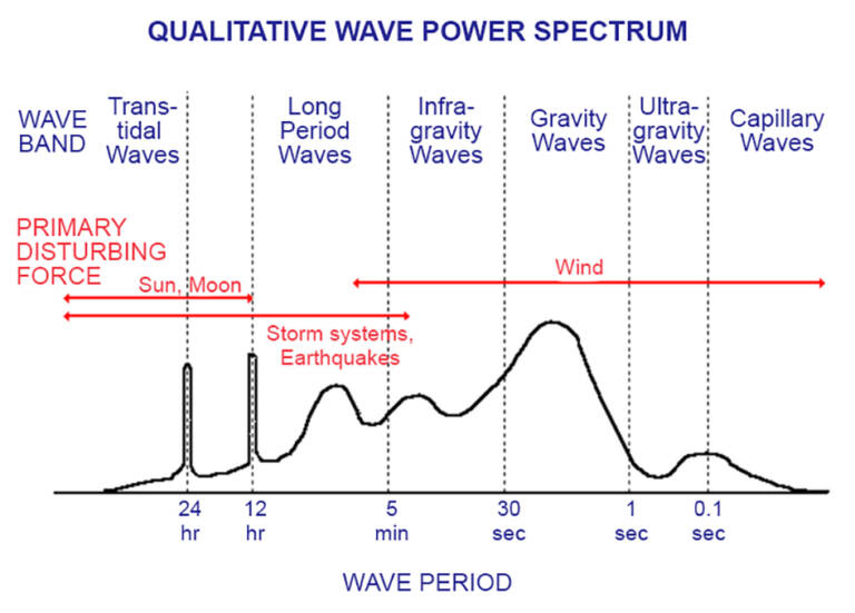
Figure: Ocean Wave Energy Spectra (Source: Kinsman, Blair, Wind Waves: Their Generation and Propagation on the Ocean Surface. Prentice-Hall, 1965, p. 23).
Those events represent a threat to the coastline in general and especially to port operations as they can compromise the safety, efficiency and comfort of operations carried out in a port or at the approach of the port. For instance, it can reduce the performance of vessel loading and unloading operations as well as the quality of the vessel stay at the port. Also, the reliability of the port infrastructure can suffer from constant wave stress damaging fixed structures and vessel mooring systems.
To face those challenges, port authorities rely on the knowledge of physical forcings like waves, winds, tides, and sea level.
A great example
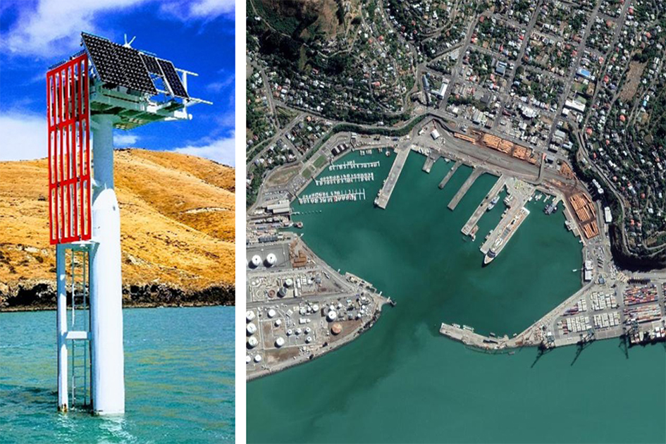
The Port of Lyttelton, New Zealand, is a great example, as it features complex water-level fluctuations inside the harbour basin. A state-of-the-art monitoring solution has been implemented comprising of two radar gauges; one positioned in the relatively sheltered inner harbour and one adjacent to the entrance channel. The Miros RangeFinder SM-140 wave radar is a IoT-enabled dry-mounted sensor measuring airgap, tide, water level, draught, and waves with millimetre-scale accuracy, in real-time, and in all weather conditions. This solution has been chosen as it provides a high data rate which is particularly helpful for discarding erroneous observations and providing reliable output at the frequencies required to resolve water-level fluctuations covering the complete wave band as described above. In contrast to the many pulsed radar gauges, the Miros SM-140 is based on a Frequency Modulated Continuous Wave approach which allows internal sampling of the distance to the water surface at up to 200Hz and reporting of results at up to 50Hz.
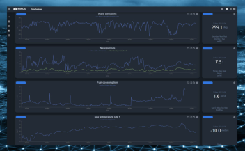
The gathered wave information has been demonstrated to be crucial to the port staff to significantly improve risk management and safety for port operations and moored vessels posed by occasional long wave events.
The monitoring of local weather and sea state conditions to actively watch the wave impact on coastlines and ports will always be a worthwhile undertaking. Thanks to innovative and smart technologies, providing real-time data has become much more convenient. All stakeholders relevant to creating, protecting, and coordinating a safe environment for work and life in and around ports and coastlines can easily get access to the same data, anytime and on any device.
Read the Port of Lyttelton case study.
Securely shared data access to key local ocean surface data provides:
- Safer navigation for vessel / cargo traffic in and out of the harbour
- Increased safety for dredging activities
- Accurate bridge clearance monitoring, especially for vessels navigating passage at high tide
- A safer work environment for divers doing maintenance / inspection work
- Valuable insight for port extension planning
- Realistic real-time data to study the harbour resilience to climate change
- Wave monitoring and Oil Spill Detection for areas with busy cargo traffic along the coast
- Real data to validate models for sea state condition prediction
- Measured current data to monitor beach erosion.
How do you improve risk management and safety for your port operations?
Smart sensor solutions from Miros can help solve your wave challenges. Miros develop novel solutions to measure the sea state and help maritime operators to improve and optimize offshore wind-farm operations and port efficiency and safety by leveraging local, digital sea-state data in real-time.
Read more about our solutions for the Ports & Coastal segment.
Find more Ports & Coastal resources: Case Studies, Webinars, Datasheets and more