Miros’ bridge clearance solution to support European river information services harmonisation project
Miros RangeFinder has been chosen to support the state-of-the-art river management system developed by the Hungarian National Association of Radio Distress-Signalling and Infocommunications (RSOE) as part of a cross border river information services (RIS) harmonisation project.


The large-scale European River Information Services Enabled Corridor Management Execution (RIS COMEX) project aims to implement and operate cross-border river information services based on the operational exchange of RIS data. The river information-based corridor services allow the authorities and logistics sector to manage traffic and transport; improve the safety, efficiency, and reliability of inland navigation; and increase environmental protections.
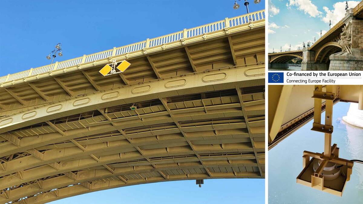
The Miros RangeFinder is a dry-mounted, radar-based sensor that measures airgap, tide, water level, draught, and waves. It provides millimetre accuracy in all weather conditions and is the only commercially available radar able to provide high accuracy bridge clearance information for the project requirements. The RangeFinder enables RSOE to provide bridge clearance information to the agreed corridor services as part of an installation on the historical Margaret Bridge, the second-oldest public bridge in Budapest.
The Margaret bridge is a key point of navigation on the Danube River and the provided data is critical for the waterway management authorities to calculate the accurate distance from the bridge to the water surface, thus ensuring safe navigation as well as allowing the vessel operators to make informed decisions as to whether they can pass under the bridge.
As the depth of the Danube under the bridge is approximately 3,6m and can increase up to 11,8m with high tide, the distance from the water surface to the bridge can diminish to less than 10m which can be critical to some vessels.
Emilie Dorgeville, VP Business Development, Ports & Renewables commented: “This is an exciting project and a great opportunity for us to showcase what RangeFinder can do in support of vessel navigation. With vessels getting increasingly bigger, the sensor gives an additional layer of information which can be fed into river information systems to provide a clearer picture and minimise navigation risk.
“Following the success of the installation, there is great potential for RangeFinder to be used for other RIS projects across the EU to increase safety and provide our clients with peace of mind.”
Gergely Mezo, Head of Project Management at RSOE added: “We provide waterway-related information to the inland navigation sector and logistics on behalf of the Hungarian Ministry of Innovation and Technology, using portals such as the PannonRIS, Danube Portal, and EURIS system, the latter being planned to become operational from April 2022 and developed within the RIS COMEX European project.
“The RangeFinder is a perfect match to deliver state-of-the-art data to improve Danube navigation management systems. The Margaret Bridge is a critical point as it’s located in the centre of Budapest, hence the potential for casualties is very high. We chose the RangeFinder as it is the only sensor available matching our requirements to provide highly accurate and reliable airgap and bridge clearance information in real-time.
“This was a challenging task as the structure of the bridge is very curved, so there is a significant difference in the available clearance between the edge and the middle of the fairway – more than four metres, and the differences in water level due to the Danube’s water flow significantly increasing the risk of accidents.
“The installation was a success with RangeFinder being easily integrated into our system. All resulting data will be made available in the corridor management system to be easily accessible to vessels operators, waterway authorities, the logistics sector, and any other stakeholders. In addition, we appreciate the nearly invisible installation of the sensor due to its small size and discrete design without altering the charm of this beautiful historical bridge.”
Corridor management aims to improve and link existing RIS services on a waterway route or network to supply RIS not just locally, but on regional, national, and international levels covering the European waterways. Through efficient corridor management, route planning and transport, traffic management can become a holistic system throughout the EU, rather than being fragmented at national levels.
The project is co-financed by the European Union as part of its ‘Connecting Europe Facility for Transport Programme’.
For further information contact: Emilie Dorgeville, VP Business Development, Ports & Renewables
About RSOE
The Hungarian National Association of Radio Distress-Signalling and Infocommunications (RSOE) is a non-profit organisation which operates the Hungarian River Information Services system, PannonRIS, the national Storm-Warning System for lakes and the national Integrated Port Management System for Danube ports (KIR). Beside operation of information systems and services RSOE coordinates and participates in EU funded projects mainly in the field of inland navigation and inland port information systems.
Learn more: https://pannonris.hu/en, www.danubeportal.com
Read more about our solutions for the Ports & Coastal segment.
Find more Ports & Coastal resources: Case Studies, Webinars, Datasheets and more